 (Download Poster)
The Rio La Paz drainage system and its effect on the
Altiplano
Gerold Zeilinger (1), Fritz Schlunegger (1), Alexander Kunov (2), Guy
Simpson (3)
(1) Institute of Geological Science, University of Bern, Baltzerstrasse 1 -
3, CH - 3012 Bern
(2) Dept. of Geological Sciences, University of Cape Town, University Avenue
13, SA - 7700 Rondebosch
(3) Geological Institute, ETH Zurich, Sonneggstrasse 5, CH - 8092 Zurich
The Altiplano developed as an intramontane basin during the orogeny of the
Andes and is today the second highest plateau on Earth. It represents a
closed basin with a distinct watershed defined by the Western Cordillera and
Cordillera Real. However, the analysis of the SRTM digital elevation
revealed two locations where the Altiplano, in its function of a sediment
trap, is not limited by the Cordillera Real, but where two drainage systems
cut into the Altiplano: 1) the Rio La Paz drainage system with a total area
of 4850 km2 and an eroded volume of approximately 3950 km3 and 2) the Rio
Consata drainage system with an area of 2300 km2 and an eroded volume of
approximately 2380 km3.
We focus on the Rio La Paz, but the Rio Consata system displays similar
geomorphic and geologic features. Field work in Rio La Paz system in
combination with morphometric analyses of a digital elevation model raises
two major questions concerning the development of this drainage system: 1)
why is the Rio La Paz cutting the Cordillera Real between the high peaks of
Nevada Illimani (6439 m) and Huara (5148 m) and 2) why is the dispersal
direction of the drainages beyond the watershed of the Rio La Paz in the
opposite direction (Fig. 1), i.e. perpendicular to the drainage divide
(pattern pointing radially away from the watershed between drainage system
and the Altiplano)?
Cross-cutting relationships between dated strata and incised valley indicate
that incision in the headwaters of the Rio La Paz in the Cordillera Real
postdates 5 Ma. Preliminary apatite fission track ages of the Cordillera
Real close to the Nevada Illimani of around 8 - 10 Ma indicate that the
major exhumation occurred during the Quechuan phase of deformation (11 - 5
Ma). The uplift of the high peaks next to the river gorge of around 1000 m
(relatively to the mean elevation of the Cordillera) could have been caused
by crustal bending (flexural feedback to erosion), which accounts for ca.
400 m, and due to enhanced local erosion, which is likely to have initiated
an additional uplift (high peaks) in an area of decreasing mean elevation.
The maximum vertical exhumation later than 10 Ma was not significant enough
to be recorded by apatite fission track.
Undoubtedly, the feedback mechanism between erosion and crustal bending
plays an important role in controlling the overall morphometry and
dispersion direction of the drainages beyond the watershed (Fig. 1). A
further possible control for initiation and location of the main valley
systems might be filling of the originally closed system of the Altiplano
and overflow, causing the rivers to erode re-incise into the previously
depositional realm. Our ongoing research will address these hypotheses in
order to better understand the active mechanisms.
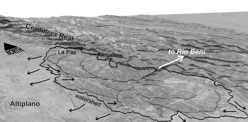
Figure 1: 3-dimensional view (Landsat
7 draped on SRTM elevation, 2 x vertical exaggeration) of the Rio La Paz
drainage system. The drainage divide between the Rio La Paz system and the
Altiplano is marked as thick line, the course of potential flow paths are
shown as thin lines.